Debug (line 260 of RequestHandler.php): Testing 'element/$ID!' with '' on SilverStripe\Blog\Model\BlogPostController
Debug (line 260 of RequestHandler.php): Testing '$Action//$ID/$OtherID' with '' on SilverStripe\Blog\Model\BlogPostController
Debug (line 267 of RequestHandler.php): Rule '$Action//$ID/$OtherID' matched to action 'handleAction' on SilverStripe\Blog\Model\BlogPostController. Latest request params: array ( 'Action' => NULL, 'ID' => NULL, 'OtherID' => NULL, )
Debug (line 184 of RequestHandler.php): Action not set; using default action method name 'index'
Senior Geochemist/Basin Modeller
Location: Hartland Quay, Devon, UK
Hartland Quay Car park (SS:223-247) to Warren Beach (SS:225-249) Access: Warren Beach is accessed via Hartland Quay slipway north of The Wrecker's Retreat Inn (SS:223-248)
Title: Folding without cracking - By Andrew Green
The cliffs north of Hartland Quay present a spectacular array of antiformal and synformal folds, including tight, straight-limbed chevron folds, which when studied provide detailed insight into structural processes which occur during major orogenic events. The orogenic collison responsible for this particular deformation was called the Variscan Orogeny. Occurring from the Late Dinantian (330.9ma) through to the Early Permian (290.1ma) this event saw both the closure of the ancient Rheic Ocean and the resultant formation of the supercontinent Pangea.
The sediments that comprise the folded cliffs at Hartland Quay belong predominantly to the Upper Namurian - Westphalian Crackington Fm (326.4ma – 315ma) and consist of interbedded quartz-rich (97%) standstone and dark grey-black shale. Deposited in a rapidly subsiding syn-orogenic foreland basin, the sandstone beds, commonly 30-60cm thick, are inferred as distal turbidites; fining upwards with sharp bases and associated sole and tool mark features. Turbiditic sands flowed E-W dominantly parallel to the basin axis into deep, largely anoxic water.
Evidence from both quartz vein fluid inclusions (formed during the main folding event) and the reflectance of vitrinite macerals indicate burial of the Hartland Quay sedimentary section to depths of ~7km against a higher than average palaeo-geothermal gradient of 38.5°C/km and subsequent uplift and erosion of 5-6km. Changes in geothermal gradient from the upper Carboniferous to the overlying unconformable Permian restrict burial, folding and uplift to a 15ma window.
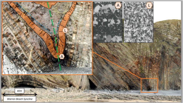
Structural investigation of the tight chevron folding (left image inset) highlights two key observations: 1) shale thickening into the fold hinge zone, and 2) sandstone beds (highlighted orange in the image), roughly uniform in thickness, folded through 300° without fracturing.
The latter phenomenon is achieved due to the extreme rates of burial soon after burial along with the high pressure & temperatures experienced by the sandstones during folding. Two photomicrographs (right image insets), showing the sandstone grain structure from the fold axis (A) and fold limb (L), record the process of quartz grain dissolution and remigration from areas of high pressure (fold limb: L) to reprecipitation in areas of low pressure (fold axis: A). In photomicrograph A the large white-light grey banded grains are the quartz reprecipitated from solution, whereas in photomicrograph L such grain sizes are absent, instead showing elongation and flattening as the remaining grains are deformed.